Jala Jala and Pagsanjan won’t fall flat for aero-loving triathletes
The road beckons. As time passes, you’ll begin to wonder, “Where does this lead?”
It’s a natural instinct. As you saddle up or make the U-turn for the trip back home, you look further down the road and think, “What if I went farther? Where will I wind up?” Riding up to Bugarin, there are at least a couple of alternatives.
Jala Jala

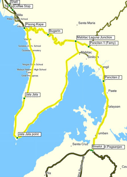
Jala Jala is a small town further south of Pililla. To get there, you make a right in the fork on the road instead of left towards Bugarin. The road will lead southwards for around 20 kilometers, past the town of Jala before turning north again towards the town of Mabitac.
The road is mostly flat with practically no turns, which makes it popular with triathletes looking for mileage while staying tucked in an aerodynamic position. Depending on the time of the year, you can face a fierce headwind on one side or the other. The road surface (cement littered with cracks) can cause pinch flats, so make sure your tires are well inflated. Upon reaching the town of Mabitac, turning left brings you back to the provincial highway and back to Bugarin from the opposite side. Coming from Pisong Kape, this is around a 64 kilometer route.
Route: Jala Jala
Starting Point: Pisong Kape
Finishing Point: Pisong Kape
Distance: 64.2 kilometers
Average Time: Two to three hours
Total Elevation Gain: +/- 937 m
Highest Point: +/- 340 m
Pagsanjan

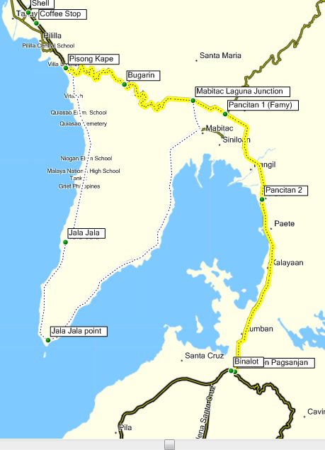
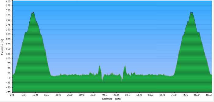
Pagsanjan, well known for the ubiquitous Pagsanjan Falls, is another 43 kilometers south of Bugarin, past the towns of Mabitac, Famy, Pangil, Paete, Kalayaan, and Lumban. The roads are virtually empty and are asphalted, making the ride smooth and fast. The road is mostly flat, climbing only in a short portion approaching Lumban as well as the access road going up to Lake Caliraya before going down again into Pagsanjan.
Route: Pagsanjan
Starting Point: Pisong Kape
Finishing Point: Pisong Kape
Distance: 86.3 kilometer
Average Time: Three to four hours
Total Elevation Gain: +/- 1,354 m
Highest Point: +/- 340 m
Variations

Depending on where you start, how far you want to ride, or how much climbing you want to do, you can take these routes in a number of ways. We’ve traveled to Jala Jala up to Pagsanjan and back through Mabitac to climb Bugarin (or vice-versa). Another option is cutting both rides short either way by making a U-turn in Pakil after stopping for lunch at Pancitan, another popular stop for cyclists. At Famy, there’s a junction leading to Real, Quezon.


